


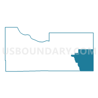
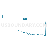
Voting District 15, Major County, Oklahoma
About
Outline

Summary
| Unique Area Identifier | 654423 |
| Name | Voting District 15 |
| County | Major County |
| State | Oklahoma |
| Area (square miles) | 103.76 |
| Land Area (square miles) | 103.46 |
| Water Area (square miles) | 0.30 |
| % of Land Area | 99.71 |
| % of Water Area | 0.29 |
| Latitude of the Internal Point | 36.25526490 |
| Longtitude of the Internal Point | -98.18936860 |
Maps

Graphs
Select a template below for downloading or customizing gragh for Voting District 15, Major County, Oklahoma


Neighbors
Neighoring Voting District (by Name) Neighboring Voting District on the Map
- Voting District 14, Major County, OK
- Voting District 2, Major County, OK
- Voting District 2, Blaine County, OK
- Voting District 205, Kingfisher County, OK
- Voting District 310, Garfield County, OK
Top 10 Neighboring County Subdivision (by Population) Neighboring County Subdivision on the Map
- Enid CCD, Garfield County, OK (53,331)
- Fairview CCD, Major County, OK (4,376)
- Hennessey CCD, Kingfisher County, OK (4,333)
- South Garfield CCD, Garfield County, OK (3,851)
- East Major CCD, Major County, OK (3,151)
- Okeene CCD, Blaine County, OK (1,525)
Top 10 Neighboring Place (by Population) Neighboring Place on the Map
Top 10 Neighboring Unified School District (by Population) Neighboring Unified School District on the Map
- Hennessey Public Schools, OK (3,859)
- Fairview Public Schools, OK (3,694)
- Cimarron Public Schools, OK (1,799)
- Okeene Public Schools, OK (1,765)
- Ringwood Public Schools, OK (1,759)
- Drummond Public Schools, OK (1,241)
Top 10 Neighboring State Legislative District Lower Chamber (by Population) Neighboring State Legislative District Lower Chamber on the Map
Top 10 Neighboring State Legislative District Upper Chamber (by Population) Neighboring State Legislative District Upper Chamber on the Map
Top 10 Neighboring 111th Congressional District (by Population) Neighboring 111th Congressional District on the Map
Top 10 Neighboring Census Tract (by Population) Neighboring Census Tract on the Map
- Census Tract 9581, Kingfisher County, OK (4,333)
- Census Tract 16.02, Garfield County, OK (4,233)
- Census Tract 12, Garfield County, OK (3,851)
- Census Tract 9551, Major County, OK (3,151)
- Census Tract 9552, Major County, OK (1,584)
- Census Tract 9586, Blaine County, OK (1,525)
Top 10 Neighboring 5-Digit ZIP Code Tabulation Area (by Population) Neighboring 5-Digit ZIP Code Tabulation Area on the Map
- 73742, OK (3,824)
- 73763, OK (1,623)
- 73768, OK (1,568)
- 73754, OK (1,078)
- 73735, OK (684)
- 73718, OK (501)
- 73760, OK (470)
- 73747, OK (285)